
Overview of Little Bardfield Parish
Location
OS Map 195. The Parish is situated in the rectangle of grid lines, Longitude 64 to 67, and Latitude 27 to 33.
Elevation: Highest point 104 metres. Lowest point 60 metres. The Postal Town is Braintree and the Post Code is mostly CM7.
The Parish is on the eastern edge of Uttlesford District in the County of Essex and falls within The Sampfords Ward electoral division in the constituency of Saffron Walden.
The eastern boundary is the River Pant which downstream becomes the River Blackwater.
The Parish boundary to the north abuts Little Sampford, to the east and south east Great Bardfield, to the south west Lindsell and to the west Thaxted.
Saffron Walden is 9 miles/14.5 kms north-west, Little Sampford is 2miles/3kms north, Finchingfield is 2.5 miles/4 kms north-east, Great Bardfield is 1.25 miles/2 kms east, Great Dunmow 8 miles/13 kms south and Thaxted is 2.5 miles/4 kms west.
1777 Map
Little Bardfield, Hawkspur Green and Oxen End are all shown on this very old map.
Essex Hundreds Map
Between Anglo-Saxon times and the nineteenth century, for administrative purposes the county of Essex was divided into 19 Hundreds. Little Bardfield Parish is in the Freshwell Half Hundred which has an area of 28,728 acres. Each hundred had a separate council that met each month to rule on local judicial and taxation matters. Perhaps this map explains why our District is named Uttlesford and the Doctor’s Practice in Finchingfield (Braintree District) is named the Freshwell Health Centre.
Area Map
This shows the location of Little Bardfield from Bishops Stortford, Hertfordshire; Saffron Walden, Halstead, Braintree, and Great Dunmow, all within Essex.
Parish Boundary Map
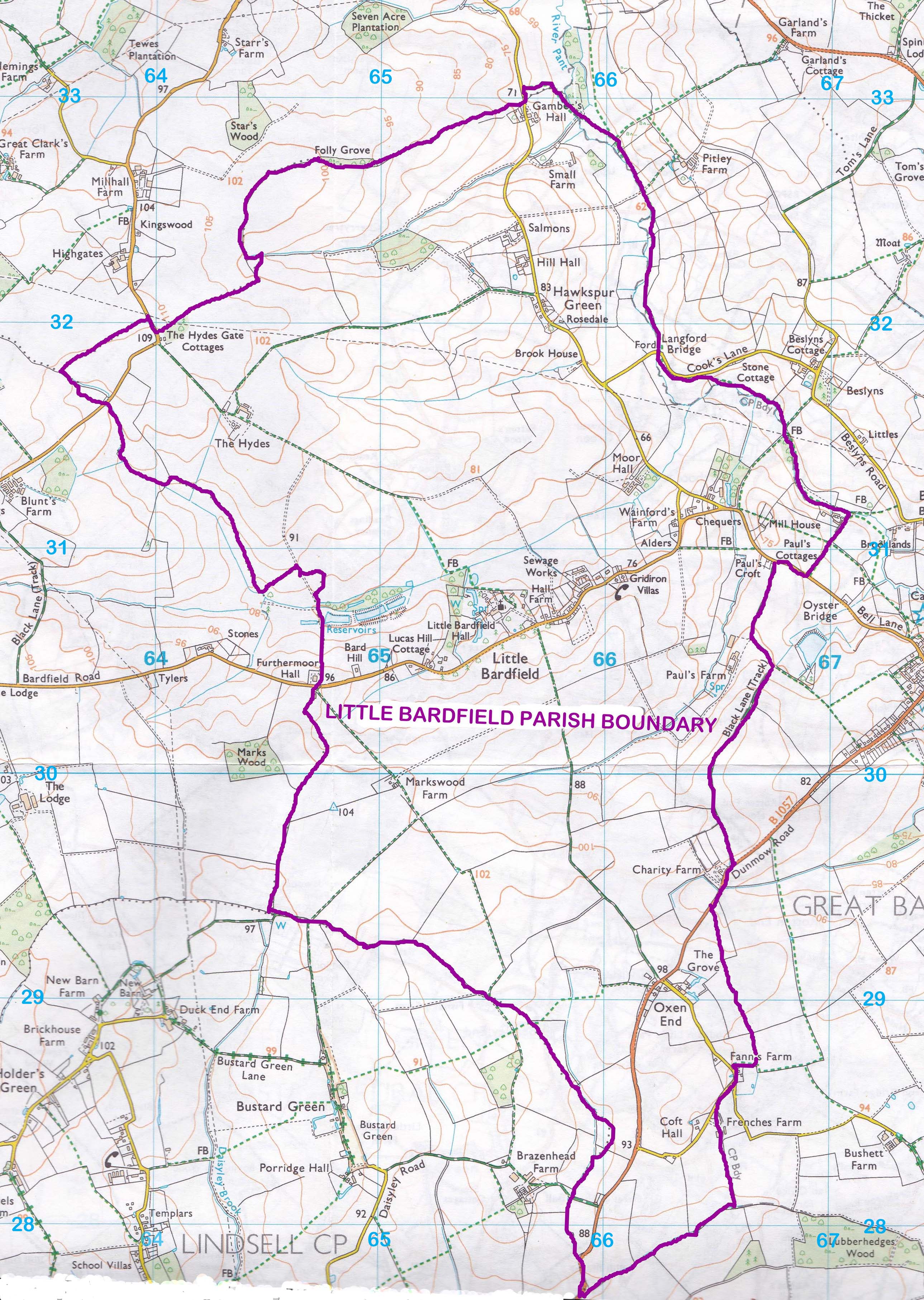
The Parishes of Little Sampford lies to the north, Thaxted to the west and Lindsell to the south. With Little Bardfield, they are all in Uttlesford District.
The Parishes of Great Bardfield lies to the east and Finchingfield to the north east, both in Braintree District.
Public Rights of Way Map
The officially numbered footpaths and bridleways are shown on this map
Parish Composition
The Parish comprises three areas: Little Bardfield Village, Hawkspur Green Hamlet to its north and Oxen End Hamlet to its south.
Little Bardfield Parish is recorded in the Domesday Survey of 1086 whilst the Church dates from before 1046.
There is one Grade 1 listed building and twenty-seven Grade 2 listed buildings.
There is little commonality of architectural design and many buildings are detached.
Some buildings have recorded histories back to the 1200’s whilst many are 300-400 years old.
The Parish is extensively active farmland with no major industrial activities.
Little Bardfield Village
OS Map 195. Grid Ref: TL 6595 3083 Lat/Long: 51.9513, 0.41350272 Height:77.5m
Residences 68. As the 2011 Census covered the whole Parish, a separate headcount for the village is not available. 139 residents were qualified to vote in the last election.
There is a post box, bus shelter, Parish Notice Board and the Village Sign.
Little Bardfield Village has one Grade 1 and eighteen Grade 2 Listed Buildings. It is a dispersed settlement and no consistent building style at any period has emerged. Some common characteristics are observable across the parish’s housing stock and the great majority of the older properties, as well as more of recent origin, do conform in their external appearance. This is more apparent in the building materials. The majority of the pre-twentieth century houses are of timber-frame construction rendered in white or pastel-coloured lime plaster, while the rest are built of redbrick, some of which are also rendered.
The minor road from Thaxted which passes through Little Bardfield is the Bardfield Road and continues as Bell Lane to Great Bardfield. It has a speed limit of 30mph which unfortunately is not always observed. There is a short pavement on north side from St Katharine’s Green to the front of the Almshouses and post box. The Village Sign and Noticeboard are opposite. Boundaries are low hedges or redbrick walls and verges on to raised open farmland, a typical Essex field boundary to a sunken roadway. Power and telephone cables all run over ground on columns and are often compromised by trees and hedges sometimes causing power failure in storms. There is no street lighting in Little Bardfield and is not wanted by the inhabitants.
An ancient footpath links St Katharine’s Church to Oxen End and many years ago was used as a burial path to the church with some ancient hedges running along it. It was then known locally as “the Coffin Way”. Footpaths radiate out from the village and a special footpath map of the area has been produced to promote their use. Cycle ways and paths are not appropriate for the narrow road in the village.
Little Bardfield OS Map
Little Bardfield Village Centre
Hawkspur Green Hamlet
OS Map 195. Grid Ref: TL 6564 3239 Lat/Long: 51.9654, 0.40966158 Height: 84.8m.
Residences 18. As the 2011 Census covered the Parish, a separate headcount for Hawkspur Green is not available. 43 residents were qualified to vote in the last election.
There is a post box and a Parish Notice Board.
Hawkspur Green was overlooked when the Parish buildings were surveyed in 1985 for Listing status. Consequently, none of its ancient buildings are Listed although there are four which should have been.
Hawkspur Green lies 1 mile/1.5kms to the north of Little Bardfield village. It is an area of special landscape value and had protected lane verges. There are wide views of surrounding farmland and to the east, the River Pant valley. Its southern boundary commences just south of Coopers Transport at Cook’s Lane. It continues north until Gamber’s Hall to the Parish Boundary with Little Sampford Parish where the Post Code changes from Braintree CM7 4SH to Cambridge CB10.
A single-track lane runs from Little Bardfield through Hawkspur Green to Little Sampford. There are no passing places for vehicles and with a deep ditch along part of the road motorists must use residents’ driveways or go onto the verges to allow any oncoming cars to get by. There are no pavements or street lighting. No speed limit is in place, but as it is a single-track road 30mph would appear to be appropriate but is frequently exceeded.
Whilst this single-track lane is un-signed and, to most people it is un-named, over the years it has had a variety of names.
These range from its original “Kings Highway”, through "Sampford Road", “Walden Lane” and “Hawkspur Green Road”.
Uttlesford District Council, without consultation, decided in 1997 to name the part of the lane in Little Bardfield Parish as "Little Sampford Road" and in 1999 at Gambers Hall Farm where the lane crosses the boundary into Little Sampford Parish, named it Hawkspur Green Road. Two names for the same lane which had previously been the one Hawkspur Green Road for its full length.
Wildlife are abundant and frequently seen are many different song birds, pheasants, partridges, egrets, sparrow hawks, buzzards, red kites, Muntjac deer, fallow deer and hares.
In season, two pheasant shoots operate, one on either side of the lane.
Although there is no mains drainage, streetlights, gas supply, shops, pubs or public transport, most residents do not see this as a disadvantage of living in Hawkspur Green.
Hawkspur Green OS Map
Hawkspur Green Centre
Oxen End Hamlet
OS Map 195. Grid Ref: TL 6626 2908 Lat/Long: 51.9354, 0.41716286 Height: 98.3m.
Residences 38. As the 2011 Census covered the whole Parish, a separate headcount for Oxen End is not available. 38 residents were qualified to vote in the last election.
There is a post box and a Parish Notice Board.
It has 9 Grade 2 Listed Buildings.
Oxen End is often passed unnoticed as there are only two wooden ‘Oxen End’ signposts at either end of a horseshoe shaped single-track lane off the main Dunmow Road, B1057. Some residences are also situated along the Dunmow Road.
It is situated two miles/3.2kms south of Little Bardfield and to get there by car it is necessary to pass though Great Bardfield. It is located at the extreme edge of Little Bardfield Parish and Uttlesford District bordering both Great Bardfield Parish and Braintree District.
There is an ancient track, Fitzridge Lane, across the fields between Oxen End and Little Bardfield which became known as “The Coffin Way” being the direct route to St Katharine’s church. In the 19th century, the land and properties near Grove House were copyhold of the Manor of Little Bardfield Hall.
They all enjoy views of the surrounding farmland, most of which is used for arable cultivation or animal grazing. There are extensive trees and hedgerows, surrounding fields and gardens which support an abundance of wildlife. Several properties are of timber construction with thatched roofs. Many are conversions from earlier farm buildings. In the past 50 years only three new properties have been built and this has meant that the rural character has been maintained. Although there is no mains drainage, streetlights or a gas supply, most residents do not see this as a negative aspect of living at Oxen End.
Oxen End OS Map
Oxen End Centre
Total Parish Census Information
1811: Males 118. Females 129. Total 247.
1911: Males 135. Females 109. Total 244.
2011: Males 132. Females 132. Total 264 of whom 244 were born in the UK.
Average age 43 years. Household spaces 107. (Source: Office of National Statistics)
At some addresses there are more than one residence. Where known, further detail will be given under the three separate areas of the Parish
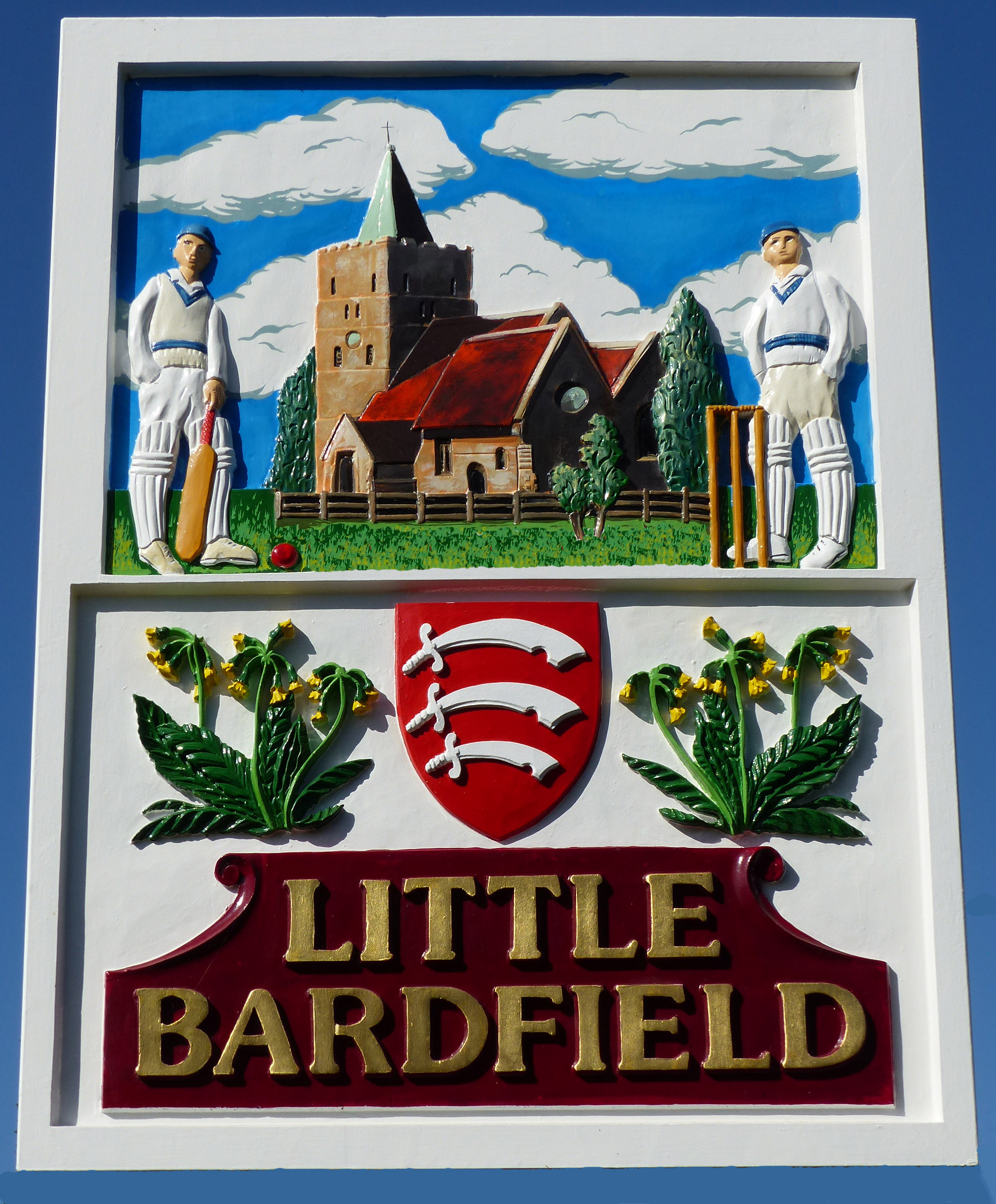
Village Sign
This features St Katharine’s Church, Little Bardfield Village Cricket Club, the unique Bardfield Oxslip, and the Essex County shield.
History Introduction
The history of the Parish is on record from pre-1046 for the Church and in the 1086 Domesday Summary. Much of this ancient History was ably assembled and summarised in 1979 by the late Mrs Eileen Judson who was resident in the village for many years and long-time member of the Parish Council. (The Judson family lived in both The White House and Wainsford Farm).
There is extensive coverage of the history of St Katharine’s Church, Little Bardfield Hall and the Alms Houses. The more recent history has been gleaned from various sources including local people’s memories, including photos from the 1920’s and happenings in WW2. This will be covered, as relevant, across the whole Parish and in the three areas of the Parish: Little Bardfield Village, Hawkspur Green and Oxen End including Buildings of Interest.
History Summary
|
River Pant: About 800BC-400AD, the word Pant was used to describe a hollow. |
|
|
1046 |
The tower and nave of St Katharine’s Church were in existence |
|
1066 |
William the Conqueror was crowned King William I of England on the 25 of December |
|
1086 |
In the Domesday Book the area is entered as Berdefelda or Birdefella which translated to Bardfield. The people count at that time included several slaves. Although the two parishes of Great and Little Bardfield were recorded as one community, they were separate as indicated by the histories of the two churches |
|
1537 |
St Katharine’s Church records of marriages and deaths existed |
|
1539 |
Henry VIII granted the Burgh of Bardfield to his Queen, Anne of Cleaves |
|
Later, Little Bardfield Parish was given by the Earls of Colne to the Abbey of Bec in Normandy |
|
|
Later, it was given by Charles I to the Haberdashers Company in London |
|
|
1653 |
The original Little Bardfield Hall was re-built as a Manor House |
|
1725 |
Some of the farms were included in a purchase by Guys Hospital |
|
1774 |
Sarah Bernard, widow of the Rev. Thomas Bernard, created funds in her Will to build a school and five terraced Alms Houses |
|
1777 |
Early maps show Little Bardfield, Hawkspur Green and Oxen End |
|
1805 |
A First Series Ordnance Survey Map shows all four locations with shading to indicate changing elevations |
|
1834 |
Under the Poor Law, Little Bardfield became part of the Great Dunmow Union and the associated workhouses |
|
1842 |
The plant name “Bardfield Oxlip” was established. This is one of the few plants/floras to carry the name of an English Village |
|
1910 |
The Brotherhood of St Paul Theological College formed in the Rectory |
|
1936 |
Hawkspur Green “Q” Camp established |
|
1938 |
The Parish Spread Eagle pub was featured on British Pathe News |
|
1942 |
Little Bardfield Hall was used by Dr Barnardo’s Homes for young children evacuated from the East End of London |
|
1950’s |
Little Bardfield Hall and Barn became a Night Club, Blues Club and Concert venue |
|
2007 |
Hawkspur Green sign boards were erected for the first time ever on the lane verge at either end of the Hamlet |
|
2009 |
Village Design Statement was constructed polling the views of the residents and considering relevant Planning Regulations regarding future housing developments |
|
2011 |
Emergency Response Plan was established to include local knowledge and equipment to co-ordinate with the professional Emergency Services in the event of a major incident |
|
2016 |
First website created to publicise the activities of the Parish Council |
|
20S19 |
New website created covering the activities of the whole Parish and its past history |
Services
Currently no public services are available in any of the three locations. However, there are many just a short drive away in nearby villages and towns.
Please refer to Commercial - Other Services
Businesses
Please refer to Commercial - Businesses
Farming
Please refer to Commercial - Farming